37.5531° N, 76.3403° W
It’s raining today along the river, and the puddles running along the roads and the edge of the woods are yellow, covered in the pollen which until early this morning hung in the air and on my body and in my lungs. It is the time of year when I most welcome the rain. Right now, I’m standing at the Chesapeake Bay where it is rainy and peaceful. I don’t get phone service when I’m out along the road near the bay, and I like it that way; I like how I’m on the edge of the continent, lost in the four thousand miles of water between here and, well, as it turns out, Sicily, where my maternal great-grandfather was born. When I’m out here out of service I feel more in touch with everywhere else, everything and everyone else, and my imagination takes control of the helm.
If my eyes could bend directly east along this vantage, I’d see through Athens where I almost went almost forty years ago and on into Tabriz, Iran, where a student of mine never came home from thirty years ago. Past there I’d move through Uzbekistan, a place I’ve never been but whose food I know well having eaten many dinners at an Uzbek restaurant in St Petersburg, Russia, where we’d spend four hours taking our time with each course and hot bread and samovars of tea, belly dancers and hookahs, and the most delicious entrees. I had no idea all these years standing waist deep in the Chesapeake at Stingray Point, I was watching distant Uzbeks.
I’m standing on the imaginary line that runs just a sliver south of the 38th Parallel, closer perhaps to 37.5, or if you speak to any one of the watermen in this village, they’ll tell you 37.5531° N.
So, close enough. Let’s go further:
Passing Gansu, China, famous for its water-pipe tobacco out into the Yellow Sea almost directly through Baengnyeong Island, which means “White Wing Island,” so named for the resemblance to an Ibis in flight, and home of intelligence communities because of its proximity to North Korea, which brings me to the most famous spot on the 38th Parallel—the 38th Parallel. Of course it runs around the entire planet almost directly under my feet, but when most people hear “38th Parallel,” they think of the Koreas, of course.
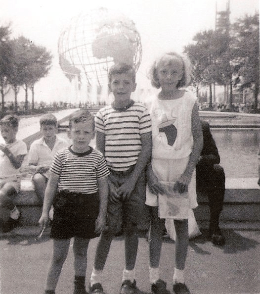
I’m on the same white line as Canyonlands National Park, Utah, and Newton, Kansas, passing right under the counter at Gurty’s Burgers. Evansville, Illinois, too, but it makes me think of the tragedy of the 1977 plane crash which took the lives of the entire University of Evansville basketball team. I’m two and a half hours east of Charlottesville, Virginia, and just south of Chincoteague Island where the horses still swim. And when I was five with my siblings at the World’s Fair in Flushing, New York, standing in front of the famous huge globe with its metal longitudes and latitudes, who were my neighbors then? Are they still out there, following different lines? Searching away? Searching toward me?
But since I find myself at the proverbial crossroads in life yet again, I can’t ignore my northern and southern neighbors—since isn’t that what we are? Neighbors? I mean, if we are going to James Webb our way into the distant galaxies and black holes, I think we’ve reached the point where we can all consider each other neighbors, relatively speaking. If “neighbor” is someone with whom we have some physical closeness compared to others more distant, than astronomy has moved us all on this sphere into the category of “neighbors” to be sure, reliant upon each other, part of each other both as particles and participants.
And those north of here include the North Pole, of course, since all longitudes meet eventually, twice actually. But closer to home is Ellesmere Island, Nunavut, Canada, the world’s tenth largest island and home to Victor’s Seafood which has curbside pickup when you don’t want to get out of the car. And Prince Charles Island, also in Nunavut, of course. This line runs south from there through Ottawa and into my birth state of New York, into Pennsylvania, into Maryland, and down through the Chesapeake Bay to this rainy little piece of Longitude. But wait, I’ve always been drawn to the tropics. Here’s why: I’m standing, I mean I find myself smack dab on the same streak that runs just west of the Bahamas and right into Holguin, Cuba, its fourth largest city and cradle of Cuban Music. But here’s the crazy part: It goes on, this longitude, into Colombia, Ecuador, and San Bartolo, Peru, on the Pacific Ocean, famous for its beach-going tourists and surfers. That’s what nearly exactly attracts people to Virginia Beach, just a notch southeast of here and where I attended high school; and where I learned in geography everything about this world except that New York and Virginia were due north of the west coast of South America. Yes, here standing on North America’s east coast and staring out toward the Atlantic, I am due north of the west coast of South America where people are staring out on the Pacific Ocean. But further still, the Southern Ocean (which I don’t remember even being a place when I was a kid) and right into the northern cliffs of Charcot Island, Antarctica, with its crabeater seals and Adelie penguins. Right here, but south.
Deltaville is at 76.3403° W for those keeping score.
This one spot, here, this mark on my mental map is tied, distantly I admit, but tied just the same to people being born and raised and looking out, wondering. It’s kind of our own little “Double L” ranch, only really thin and exceptionally long. If we coordinate correctly, we could all plant flowers on our line, though somewhat problematic headed north and south as my daffodils might not grow in the Nunavut tundra or the desert of Patagonia, but we are neighbors; we work together on these things.
We have been nomads since the nomadic days, and while we might be “from” somewhere, we rarely stay any longer, following our songlines, chasing something unknown. Since I’m a child I have wanted to follow those latitudes and longitudes, since I read Robin Lee Graham’s Dove, since Joshua Slocum, since St. Brendan.
I want to meet our neighbors before I sail on to different coordinates. Ireland, of course, and Prague. Spain again, and the Netherlands, for certain. It turns out these lines are everywhere, like a grid, like graph paper, like those moving walkways in airports leading us to the next terminal.